| ||||||||
The Center for Ecological-Noosphere Studies of NAS RA (CENS) and the Institute for Informatics and Automation Problems of NAS RA (IIAP) jointly with the University of Geneva, Switzerland, are developing a multidimensional information system to collect and process satellite data (data cube) for the creation of a remote sensing system for ecological monitoring of landscapes in Armenia (http://datacube.sci.am). The work was based on the experience of the University of Geneva in creating the Swiss Earth Observation Data Cube. https://www.swissdatacube.org/ "The two-year work has made it possible to collect satellite data in a national repository, which includes the full archive of Landsat and Sentinel-2 satellite imagery, as well as images obtained from unmanned aerial vehicles (UAV). An algorithm for distinguishing and delimitation of water bodies has been developed in the system, using the Python programming language, it is planned to become a tool for decoding water bodies from satellite imagery in the information system," said Shushanik Asmaryan, the head of the Geographical Information System and Remote Sensing Department of CENS, candidate of geographical sciences. She noted that satellite data are one of the most important sources of reliable environmental information and have become an inseparable part of assessment and monitoring of the ecological state of the environment. "Despite their great advantages, these data have a problem. They are high-volume data and require computing resources for their processing. While studying spatio-temporal changes of geographical phenomena, for example, pasture degradation, lake water quality, forest cover changes, etc., in the case of several hundred or thousand images, high computational resources are needed to process the images. Those technologies are called Earth observation multi-dimensional systems (data cube)," said Shushanik Asmaryan. According to her, today freely available data cubes, such as the Google Earth Engine (GEE) system, have already been developed, and are widely used by the scientific community and decision-making organizations. However, in such systems, depending on the amount of data, the free use of the system is limited. And the availability of such systems for making science-based decisions at the national level is becoming important and even imperative year by year. "Our National Earth Observation Data Cube is crucial in the implementation and application of satellite data in the process of informed decision-making. It is noteworthy that in 2022, Armenia entered a new phase of space research and space technologies development due to the existence of its own satellite. The presence of a national image processing platform is already becoming imperative. It is still in the embryonic stage and has to go a long way of development to become a national platform equipped with tools and computing resources for satellite data processing," said Shushanik Asmaryan. She noted that there is a great reaction among the geographical information international community to initiatives aimed at national data cubes, including the Armenian example. "The results of the work were reported in 2021 at the International scientific conference "The Platform for Advanced Scientific Computing-PASC 2021" (https://pasc21.pasc-conference.org/) held on July 5-9 in Switzerland. The Group on Earth Observation (GEO) - https://www.earthobservations.org/index.php is also greatly interested in the results of the work which are regularly presented in GEO annual reports," Shushanik Asmaryan noted. The work was carried out within the framework of the "Armenian Data Cube for Sustainable Development - ADC4SD" project. It was funded by the Swiss State Secretariat for Education Research and Innovation within the framework of a Seed funding grant program. Most of the working group’s experts are young scientists. The following scientific articles were published on the work:
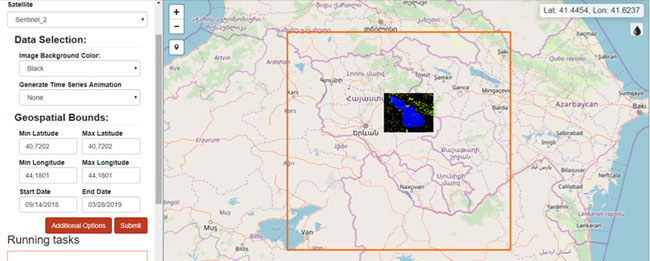
Armenian Earth Obseravtion data cube environment
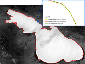
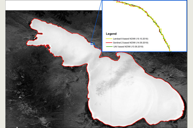
Delineation of Lake Sevan using the NDWI spectral index in a data cube environment from medium-resolution Landsat (30m), high-resolution Sentinel (10m) satellites, and ultra-high-resolution (0.16m) UAV images |
General Page - About Academy - Divisions - Organizations - Members - Contact us - Structure - Presidium Members
Documents - Innovation Proposals - Publications - Funds - Conferences - Competitions - International cooperation
Youth programs - Photogallery - Videogallery - Web Resources Other Academies - "Gitutyun" newspaper - "In the World of Science" Journal
Publications in Press - Notices - Anniversaries - Universities - News - Scientific Results - Diaspora Department presents
Young Scientist Tribune - Our Honored Figures - Announcements - Sitemap - COVID-19 - Search